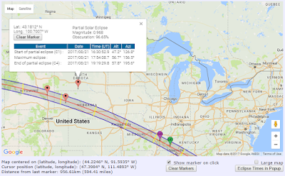
Found it, again! I had seen the interactive Google Map for the August 2017 solar eclipse path before but then lost track of it. While checking out the EclipseWise.com website and examining the index of the summer eclipse page, I spotted it: the Interactive Google Eclipse Map.
The key feature is that when you click on the map in a particular location, it will drop at marker and then in the pop-up show you the circumstances of the eclipse.
The screen grab above is not dynamic; it is a static snapshot.
If you're outside of the path, of course, you'll only experience a partial eclipse and only see first and fourth contact. When you choose a point in the shadow path, you'll enjoy all four key moments.
I like how the tool shows the times along with the altitude and azimuth of the Sun and the magnitude and obscuration values. The map also shows the points of greatest duration and greatest eclipse.
Friday, May 12, 2017
Subscribe to:
Post Comments (Atom)


No comments:
Post a Comment